Watershed Management Plan: Roosevelt Creek
Welcome
The Roosevelt Creek Watershed Management Plan (WMP) is a project funded by Pinellas County and the Southwest Florida Water Management District to provide an evaluation of the watershed, develop a stormwater model, and identify problems and recommend solutions for flood reduction, and improvements in water quality and natural resources within the watershed.
The results of this study are for a Pinellas County flood map update in the watershed, not a FEMA flood map update or for flood insurance revisions, at this time. The ultimate goal of this project is to gain a better understanding of the watershed’s stormwater conveyance system and recommend projects that will reduce flooding and protect/restore the natural resources.
Overview
The Roosevelt Creek Watershed is located in a highly developed portion of Pinellas County. The watershed encompasses about 12.6-square miles and includes parts of the cities of Pinellas Park and St. Petersburg. The Roosevelt Creek Watershed is bounded to the north and east by Old Tampa Bay, to the south by the Tinney Creek and Sawgrass Lake Watersheds, and to the west by the Cross Bayou Watershed. Discharges from the Roosevelt Creek Watershed flow from south to north into tidal marsh areas along Old Tampa Bay through a system of storm drains and open ditches. Six tributaries drain the watershed with Channel 5 being the largest in the basin.
The watershed is characterized by low topographic relief ranging in elevation from about 25 feet (NAVD88) at the headwaters along the southwestern boundary of the watershed, to 1 foot in the vicinity of Old Tampa Bay. There are also isolated portions of the watershed that extend to higher elevations such as the landfill and roadway overpasses. The watershed is highly developed. The central half of the watershed is comprised of industrial parks and public works facilities (e.g., the landfill, water treatment, etc.). The surrounding areas of the watershed are primarily residential. The primary conveyance through the watershed starts at its southern end at the Roosevelt Creek Stormwater Facility. This facility outfalls to the north via a series of channels and enclosed pipe systems and ultimately to Old Tampa Bay through Channel 5.
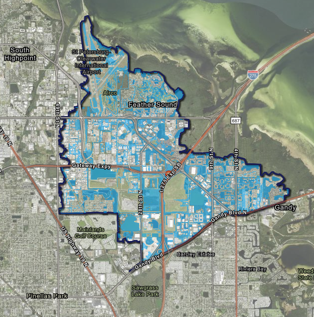
Community Input
For this project, we appreciate your feedback on the Roosevelt Creek WMP 100-Year Floodplain Draft map viewer. We would like your help in verifying floodplain map accuracy based on personal experiences in the watershed. Input on any areas within the community that differs from the preliminary flood condition findings would be extremely helpful to this project’s final analysis. This information will allow us to refine our model and provide the best solutions to issues within the Roosevelt Creek watershed.
- To access the viewer, click on the map below. (This will take you to the map viewer application where you can explore the 100-year floodplain throughout the watershed.)
Roosevelt Creek WMP Floodplain Map Viewer
Background
What is a watershed?
A watershed is an area of land that drains to an open body of water, such as a stream, river, lake or ocean (USGS, SWFWMD). No matter where you live on earth, you live in a watershed! Watersheds are crucial because they act as natural drainage systems, regulating flows and collecting and channeling water, while also filtering pollutants. In doing so, watersheds buffer us from flooding, provide clean drinking water, support diverse ecosystems, and offer opportunities for recreational activities.
Watershed Management Plan Development
Pinellas County takes a watershed-wide approach to managing water and water-related resources within its boundaries. By doing so, all characteristics of each watershed can be evaluated to reflect the real, interconnected nature of our water resources. This allows the County and its partners to clearly identify, prioritize and address issues related to the watershed’s water resources. Pinellas County plans to develop a Watershed Management Plan for each of its watersheds. These plans guide the County in providing flood protection, protecting and managing environmental resources, and achieving improvements in water quality in County waters. This approach provides a method to evaluate the capacity of a watershed to improve flood protection while finding ways to enhance and restore water quality and natural systems. To learn more, watch the County’s watershed planning process video.
Contact Us
Rob Burnes
Project Manager
Public Works / Environmental Management
22211 US Hwy 19 N., Clearwater, FL 33765
(727) 453-3149
rburnes@pinellas.gov