
Alligator Creek Watershed
Open House Information
Attend an open house to learn more about changes to your property’s flood zone or base flood elevation.
Sept. 12: 9:30 a.m. – noon, Clearwater East Community Library
Sept. 30: 4 p.m. – 7 p.m., Safety Harbor Public Library
Nov. 10: 10 a.m. – 1 p.m., Clearwater East Community Library
Overview
The Alligator Creek Watershed is located in a highly developed portion of Pinellas County. The watershed encompasses nearly 8.7-square miles and includes parts of Unincorporated Pinellas and the cities of Clearwater and Safety Harbor. The Alligator Creek Watershed is bounded by nine watersheds including Curlew Creek and Mullet Creek to the north and Stevenson’s Creek and Allens Creek to the south.
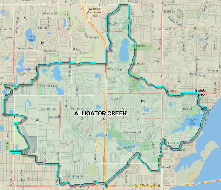
There are two main channels in the watershed, Channel A, also known as Alligator Creek, flows mainly from west to east, is just over 5 miles long, and discharges into Alligator Lake. Channel B runs approximately 2.4 miles, originating at Lake Chautauqua then flowing south into Alligator Lake. Alligator Lake ultimately discharges into Old Tampa Bay near downtown Safety Harbor. The watershed includes 3 lakes Alligator Lake, Moccasin Lake, and Lake Chautauqua.
The watershed is characterized by topographic relief ranging in elevation from about 93 feet (NAVD88) along the northern boundary of the watershed, to 4 foot in the vicinity of Alligator Lake near Old Tampa Bay. The watershed is highly developed with residential land use dominating the watershed. It also has a commercial corridor along US Highway 19, as well as several interconnected multi-use trails.
FEMA Preliminary Flood Map Update
FEMA has released a new preliminary flood map for the Alligator Creek Watershed in Pinellas County. This watershed encompasses unincorporated Pinellas County and the cities of Clearwater and Safety Harbor.
How Will This Affect My Property?
The updated map may mean changes in flood risk and insurance requirements for property owners and renters.
- When the new FEMA Flood Insurance Rate Map (FIRM) for the Alligator Creek Watershed is adopted, your flood insurance requirements may change.
- You may be required to purchase flood insurance, or your premium may change.
- The FIRM highlights high-risk areas, known as the Special Flood Hazard Area, where flood insurance is mandatory for most mortgage holders.
- The FIRM also identifies moderate and low-risk areas where flood risk is reduced but not entirely removed.
Why the Flood Maps Are Being Updated
Because flood hazards change over time, flood maps are updated periodically to reflect the most updated flood risk for the community. As part of the Alligator Creek Watershed Management Plan, Pinellas County, the City of Clearwater, and the Southwest Florida Water Management District commissioned a detailed hydrologic and hydraulic study of the watershed. That study used modern LiDAR-based elevation data and a much finer level of modeling detail than was available when the original FEMA flood maps were created — dividing the watershed into more than 1,000 individual subbasins rather than relying on broader, coarser topographic contours.
The result is a floodplain study and map that is significantly more precise than the currently effective FEMA products. The updated analysis identifies roughly 1,390 acres within the 100-year floodplain, compared to about 975 acres shown on the existing FEMA maps — a difference driven by the improved topographic detail. In several areas, this newer, more accurate data reveals flood-prone areas — including depressions, small lakes, and low-lying neighborhoods — that weren’t captured by the older, coarser mapping methods.
Next Steps and Taking Action
- Visit the FEMA Flood Map Changes viewer to review your property’s preliminary flood map changes.
- If you are affected, contact your insurance agent to discuss potential changes to your policy.
- Purchase flood insurance for your home, business, or rental. You may be eligible to receive the Newly Mapped discount if you purchase or renew a flood insurance policy within the first 12 months after the map update.
Public Appeals and Comments
A formal appeal process is available for residents to submit comments or dispute the map changes.
- The 90-day appeal period began on Aug. 19, 2026.
- The 90-Day Appeal and Comment Period will officially end on Nov. 17, 2026.
- Citizens are encouraged to contact our office for more information.
Additional Resources
- Flood Insurance Technical Assistance
- Pinellas County Floodplain Information
- State of Florida’s Floodplain Management Program
- FEMA Flood Insurance Advocate
Contact Us
Floodplain Management
(727) 464-7700
floodplain@pinellas.gov