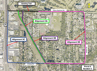
Pinellas Trail South Gap Alignment Development Process: Phase II – Segment 3
- Limits: Whitney Road to Haines Bayshore Road
- Trail uses Duke Energy Easement, sidewalk easements, County right-of-way
- 0.58 miles of new trail
- Alternative alignments studied:
- Alignment 3A: Along the Duke Energy property, from Whitney Road to Haines Bayshore Road
- Alignment 3B: Along the Duke Energy property and the west side of Cardinal Drive
- Alignment 3C: Along the south side of Whitney Road and east side of US19
- Alignment 3D: Along the south side of Whitney Road to the east side of Wolford Road and south side of Haines Bayshore Road
 Pinellas Trail South Gap Alignment Phase II – Segment 3 project map
Phase II – Segment 3 Alignment Comparison
|
Element |
Alignment 3A Duke Energy Corridor |
Alignment 3B Cardinal Dr. Corridor |
Alignment 3C US19 Corridor |
Alignment 3D Wolford Rd. Corridor |
|
Side street speed limit (mph) |
No streets |
25 |
35 |
30 |
|
Length of route |
0.58 miles |
0.65 miles |
0.88 miles |
1.51 miles |
|
Total crashes (5 years) |
0 |
0 |
12 |
10 |
|
Street/driveway crossings (total) |
0 |
1 |
21 |
18 |
|
Partially shaded |
Yes |
Yes |
No |
No |
|
Scenic views |
Open green space |
Some |
None |
None |
|
ROW/Easement needs from different property owners (totals) |
2 |
1 |
7 |
1 |
|
Wetland impacts |
Low |
Medium |
Low |
Low |
|
Floodplain impacts |
Low |
Medium |
Medium |
Medium |
|
Utility impacts |
Low |
Low |
High |
Medium |
|
Cost |
$ |
$$ |
$$$$$ |
$$$$ |
Return to Development Process page
