
Beach Nourishment and Easements
Pinellas County Beaches
There are 35 miles of beaches in Pinellas County and 12 miles are regularly nourished by U.S. Army Corps of Engineers and Pinellas County. Along undeveloped shorelines, sand movement is often not detrimental and may go unnoticed. However, the changes in beaches along developed shorelines are often very evident and detrimental to beachfront properties.
Prior to beach nourishment in Pinellas County, many municipalities had thin, non-protective beaches or no beach at all. Over successive nourishments, the beaches from Clearwater to St. Pete Beach have been built up with more than 10 million cubic yards of sand. The Coastal Management program helps preserve our beaches, which are essential in maintaining the quality of life that residents value and which attracts visitors throughout the year.
Beach Nourishment Locations managed by Pinellas County
History
Throughout the 19th and 20th centuries, both natural and human-induced changes occurred along the barrier islands. The hurricanes of 1848 and 1921 breached new tidal inlets at John’s Pass and Hurricane Pass. In the 20th century, many inlets experienced significant changes in tidal prism due to dredge-and-fill and causeway construction in back-barrier bays. The combination of unregulated coastal development and the destabilization of many tidal inlets led to significant beach erosion issues in the mid-20th century. Beachfront homeowners attempted private shore protection by building seawalls and short groins. Regional sediment transport patterns were not considered in these efforts and many of the private structures were not successful.
By the 1960s, much of Pinellas County’s coastline had eroded to the seawalls. Little sand remained along much of the developed shore.
A federal shore protection project was initiated along 100 percent of Pinellas County’s developed shoreline in 1966. The project includes the developed barrier islands of Clearwater Beach, Sand Key, Treasure Island and Long Key (the latter three are the active projects).
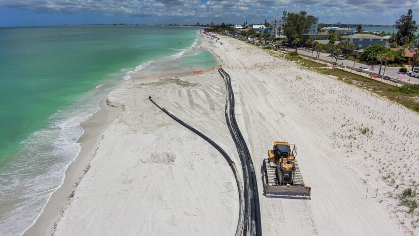
By the 1970s, beach nourishment had become the preferred method of shore protection because unlike structures, it addressed the problem of a lack of sand in the nearshore system. Beach nourishment is the process of adding sand to an eroding beach to advance the shoreline seaward. Typically, dredged sand is pumped onto an eroding beach through a pipeline and the sand is distributed by bulldozers. Beach nourishment is intended to occur at regular intervals in order to provide enough sand to decrease erosion for a certain number of years.
Today, nourishment remains the core of the Florida program and structures are installed sparingly, only after much study and only when nourishment alone does not control the erosion.
U.S. Army Corps of Engineers & Easements
The first federal authorization for beach nourishment in Florida was in 1966 for Treasure Island. Since 2015, Pinellas County has worked to get U.S. Army Corps of Engineers (USACE)-compliant easements for Sand Key while at the same time coordinating with the USACE and members of Congress on changes to the easement language. In 2023, USACE determined that the Treasure Island and Upham Beach segments were also missing compliant easements and cancelled the scheduled nourishment.
Traditionally, the federal cost share has covered ~65% of the project costs leaving the county to only pay 17.5% after State grants.
The 2026 agreement between Pinellas County and USACE creates new avenues for securing federal dollars to support beach nourishment in Pinellas County. This new agreement softens the Corps’ easement policy by:
- Allowing the Corps to cost-share seaward of ECL for areas where there is no landward public access.
- Allowing the County to pay for areas where there is no public access.
- Allowing easements to be for the duration of the project authorization.
- Allowing public use through public use ordinances in lieu of public use in the easement.
- Clarifying that public use is of the sandy beach and not on the vegetated dune.
Construction easements from beach-front property owners are still needed for 100% of the properties in the beach nourishment projects. As of May 2026, only 70% of properties in the Sand Key project area have signed and recorded compliant easements.
Property Owners & Easements
Property owners retain ownership of their property. The easement provides permission for specific beach nourishment-related construction activities only. Previously recorded perpetual easements in the project area remain valid. Although easements are no longer required to be perpetual, we highly recommend signing a perpetual easement to ensure the long-term stability of the project. If required easements are not secured, portions of the beach nourishment project may be unable to proceed.
Unless you have previously signed a perpetual easement, you most likely will need to sign an easement for upcoming projects. Please note, previously recorded temporary construction easements, both dune and no dune options, signed for the 2024 beach nourishment project are only valid until Dec. 31, 2029 and are not compliant to receive federal funding.
- Valid USACE easements can be tracked on the Beach Nourishment Easement Acquisition map.
- For more information on easements and your property, email signforsand@pinellas.gov
What are an Erosion Control Line and a Coastal Construction Control Line?
An Erosion Control Line (ECL) is a boundary line fixed by the state on a nourished beach dividing private (landward) and public (seaward) property. See Florida Statutes, Section 161.191. It is typically set at the mean high water line and established before the first nourishment. See Florida Statutes, Section 161.161(5). The ECL can be found on the erosion control line map.
In the state of Florida, the establishment and approval of an erosion control line is required before the initial construction of a nourishment project. In the Indian Rocks Beach and Redington Shores areas, ECLs were established in several segments before the initial beach nourishment. Because of the successive cycles of nourishment, the ECL, which does not move, is now located within the dunes in many areas.
The Coastal Construction Control Line (CCCL) is a line of jurisdiction, defining the landward limit of the Florida Department of Environmental Protection’s authority to regulate construction. The CCCL program protects the beach and dune system from upland construction that could weaken, damage or destroy the integrity of the system.
According to Florida law, beach property seaward of the erosion control line is state land. However, sand must often be placed landward of the ECL to restore the proper slope, elevation and function of the beach. The area landward of the Proposed ECL remains the property of the upland owner, irrespective of future beach erosion or accretion. Property seaward of the Proposed ECL will remain the property of the state, will be public beach, and will not impair upland owners’ riparian rights. Easements are needed in advance to ensure the entire beach requiring sand can be restored.