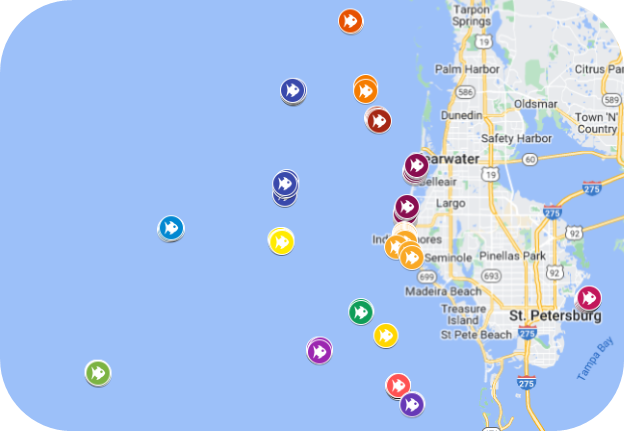
Artificial Reef GPS Coordinates
Click on the image below to view an interactive map of the 43 reefs.
Note: Storms can shift the locations of reef components over time, so GPS coordinates may not be exact.
Reefs of particular interest for diving and fishing
| Name | Latitude | Longitude |
|---|---|---|
| Indian Shores Reef: John's Pass Bridge material | 27º - 51.774 N | 083º - 01.725 W |
| Indian Shores Reef:WWII Navy landing craft | 27º - 51.441 N | 083º - 01.833 W |
| Rube Allyn Reef:Scattered concrete material | 27º - 56.021 N | 083º - 01.514 W |
| St. Pete Beach:200-foot barge | 27º - 40.600 N | 082º - 51.750 W |
| St. Petersburg Bay Reef:Scattered concrete material | 27º - 47.270 N | 082º - 35.550 W |
| South County Reef: 80-foot tug boat “Orange” | 27º - 43.375 N | 082º - 58.450 W |
| Veterans: three barges and two plaques honoring veterans | 28º - 03.000 N | 083º - 00.750 W |
| Pinellas #2: U.S. Coast Guard Cutter "Blackthorn" | 27º - 52.598 N | 083º - 11.164 W |
| Pinellas #2: 180-foot tug boat "Sheridan" | 27º - 52.578 N | 083º - 11.150 W |
| Treasure Island II:50-foot steel trawler | 27º - 41.686 N | 083º - 17.547 W |
| Treasure Island II: 85-foot steel hull shrimp boat | 27º - 41.751 N | 083º - 17.557 W |
Have you visited an artificial reef recently?
Share your photos with us! Upload them to Pinellas County’s Flickr page or upload them to the map linked above.
Questions?
For more information regarding reef locations, email recycle@pinellas.gov.
Additional Resources
- Where Does It Go? Search Tool
- Recycle Guide & Downloadable Signage
- Household Chemical Collection
- Collection: Garbage & Recycling
- Hours: Solid Waste Disposal Complex
- Disposal Fee Information
- Educational Resources: Garbage and Recycling
- Recycling FAQ
- Map of Recycling Drop-Off Centers
- Artificial Reef Program
- Mulch Pickup Program
- For Businesses: Garbage & Recycling Resources
- How Mixed Recycling Works In Pinellas County
- Video Library: Garbage and Recycling
- Holiday and Gift-Giving Guide
- Pinellas Partners in Recycling
- Waste-to-Energy Facility
- Bridgeway Acres Landfill
- Solid Waste Master Plan
- Solid Waste Disposal Accounts
- Lealman Garbage and Recycling Collection
- Tampa Bay Recycles
- Why Recycling Is Important
- Discover Careers with Pinellas County Solid Waste
Updated on April 1, 2026.